Kirriemuir to Forfar active travel route

Share Kirriemuir to Forfar active travel route on Facebook Share Kirriemuir to Forfar active travel route on Twitter Share Kirriemuir to Forfar active travel route on Linkedin Email Kirriemuir to Forfar active travel route link

Consultation has concluded

Help us create a route for residents to walk, wheel or cycle between Kirriemuir and Forfar.


About active travel

Active travel means travelling in physically active ways. For example, walking, wheeling or cycling.

Active travel has economic, social, health and environmental benefits. It is a key priority for the Scottish Government and Angus Council. The Scottish Government has committed to reduce car kilometres travelled by 20% by 2030.

Our proposals

We want to make it easier for people to travel between Kirriemuir and Forfar through active travel means. We've been working with Amey to develop some key themes that were explored in a previous study.

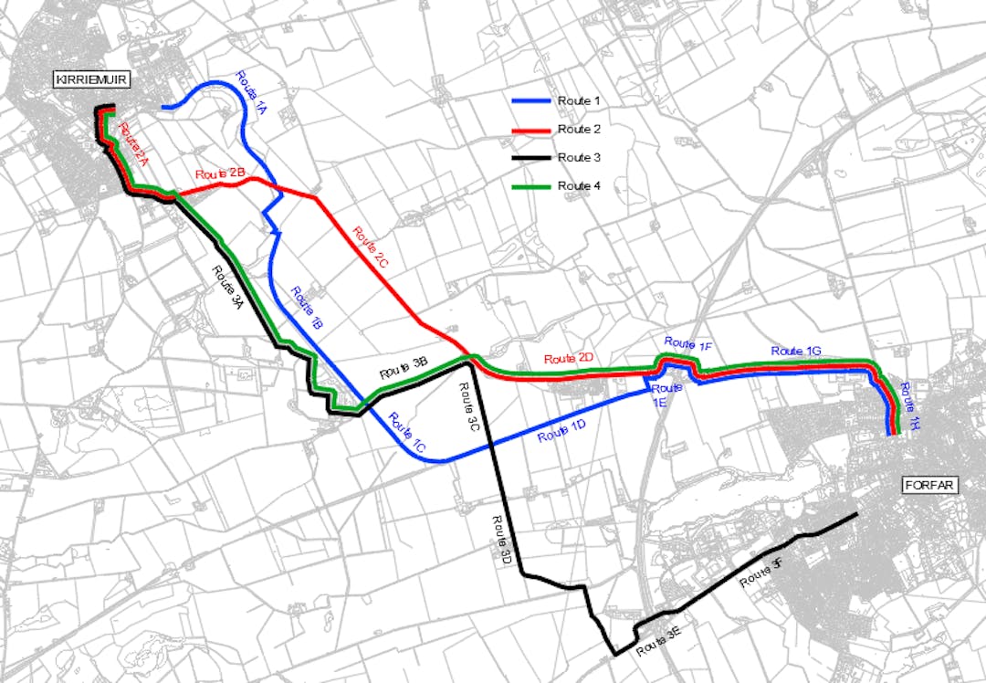
Four routes have been put forward. We're looking for your preferred option.

The four route options are:

Route 1

A new shared footway provision that will follow the old derelict railway from Marywell Gardens until it joins the A926 east of Padanaram. The route then follows a widened footway along the A926 until the centre of Forfar.

Route 2

This route requires on road cycling with a reduced 20mph speed limit until Rosewell Road. The 6km route then follows a widened footway alongside the A926 until it ties in with the above derelict railway, again following a widened footway along the A926 until the centre of Forfar.

Route 3

Requires the same on road cycling with reduce speed limit until Rosewell Road, where on road cycling will then continue along these side roads with a reduced 40mph speed limit until it connects with the A94. The last 2km of route utilises a mixture of widened footways and on road cycling until the centre of Forfar.

Route 4

Combines the above routes, the route will follow Route 3 until it connects with the A926 east of Padanaram, then follows Route 2 into the centre of Forfar.

How to get involved

Take a look at the maps and drawings of the proposed routes elsewhere on this page.

Then give us your views on the four options, and tell us which one you feel is the best, by completing the survey .

You can also come along to our events and tell us your thoughts in person. We'll be at Kirrie Connections on Monday 26 February from 9:30am to 5pm and then Forfar Library on Tuesday 27 February from 2pm to 8pm.

What happens next

The survey closes on 4 March 2024.

We'll use your responses help us progress the project and identify possible funding opportunities.

Sign up for updates to stay informed of progress.

Help shape active travel in Angus.

Help us create a route for residents to walk, wheel or cycle between Kirriemuir and Forfar.


About active travel

Active travel means travelling in physically active ways. For example, walking, wheeling or cycling.

Active travel has economic, social, health and environmental benefits. It is a key priority for the Scottish Government and Angus Council. The Scottish Government has committed to reduce car kilometres travelled by 20% by 2030.

Our proposals

We want to make it easier for people to travel between Kirriemuir and Forfar through active travel means. We've been working with Amey to develop some key themes that were explored in a previous study.

Four routes have been put forward. We're looking for your preferred option.

The four route options are:

Route 1

A new shared footway provision that will follow the old derelict railway from Marywell Gardens until it joins the A926 east of Padanaram. The route then follows a widened footway along the A926 until the centre of Forfar.

Route 2

This route requires on road cycling with a reduced 20mph speed limit until Rosewell Road. The 6km route then follows a widened footway alongside the A926 until it ties in with the above derelict railway, again following a widened footway along the A926 until the centre of Forfar.

Route 3

Requires the same on road cycling with reduce speed limit until Rosewell Road, where on road cycling will then continue along these side roads with a reduced 40mph speed limit until it connects with the A94. The last 2km of route utilises a mixture of widened footways and on road cycling until the centre of Forfar.

Route 4

Combines the above routes, the route will follow Route 3 until it connects with the A926 east of Padanaram, then follows Route 2 into the centre of Forfar.

How to get involved

Take a look at the maps and drawings of the proposed routes elsewhere on this page.

Then give us your views on the four options, and tell us which one you feel is the best, by completing the survey .

You can also come along to our events and tell us your thoughts in person. We'll be at Kirrie Connections on Monday 26 February from 9:30am to 5pm and then Forfar Library on Tuesday 27 February from 2pm to 8pm.

What happens next

The survey closes on 4 March 2024.

We'll use your responses help us progress the project and identify possible funding opportunities.

Sign up for updates to stay informed of progress.

Help shape active travel in Angus.

  • CLOSED: This survey has concluded.

    Tell us which route option you like and any issues that you associate with the options presented. 

    Consultation has concluded
    Share Kirriemuir to Forfar active travel route survey on Facebook Share Kirriemuir to Forfar active travel route survey on Twitter Share Kirriemuir to Forfar active travel route survey on Linkedin Email Kirriemuir to Forfar active travel route survey link